Signature reports

Divided by Design

“Divided by Design” uncovers the profound impacts of transportation decisions on socio-economic and environmental landscapes, revealing a legacy of division that continues to affect marginalized neighborhoods.

Created by Design: Historic Inequities in U.S. Transportation

The devastation, disconnection, and displacement resulting from plowing highways through cities and neighborhoods is easy to see, but rarely do we quantify the costs in terms of lost wealth, land, residents, and businesses. In addition to the look at the history below in Part I, we also examine current and historical data on the impact of one built and one unbuilt highway in Atlanta, Georgia and Washington, DC in an attempt to quantify what was lost—and what could have been lost.

The Interstate age: Damaging divisions, created by design

In a scene repeated all across the country, this 1968 photo (looking west—Washington Monument visible at top right) shows historic southeast District of Columbia neighborhoods soon to be demolished as construction on Interstate 395/695 continues eastward. The historic Marine Barracks is visible in the middle right. Credit: District of Columbia. Department of Highways and Traffic and District Department of Transportation, “Southeast/Southwest Freeway,” DDOT Historic Collections, accessed June 13, 2023.

History quantified: Examining the damage in Washington, DC

Highways built through cities have caused clear devastation, disconnection, and displacement, but the costs in lost wealth, land, residents, and businesses are rarely quantified. We analyze data on one built and one unbuilt highway in Washington, DC (and similarly in Atlanta) to measure both the actual and potential impacts.

History quantified: Examining the damage in Atlanta, GA

The visible devastation, disconnection, and displacement caused by highways through cities is clear, yet the costs in lost wealth, land, residents, and businesses are rarely quantified. We analyze current and historical data on one built and one unbuilt highway in Atlanta, GA to assess both the actual and potential damage.

From Convoy to Concrete: How Eisenhower's Vision for the Interstate Highway System Shaped Urban and Rural America

As the story goes, after being shaped in his youth by a long and delay-filled trip in a military convoy across the United States on the country’s limited network of small highways and backroads in 1919, President Dwight Eisenhower advanced plans to create a national network of interstate highways.

The Federal-Aid Highway Act, passed during his administration in 1956, established the program for funding and building the new system. The primary intent of the interstate was to connect cities (busy, multimodal, economic hubs) and states with a new high-speed form of travel with limited access to minimize delays. While history is unclear on this point, there’s some evidence that President Eisenhower (or some in his administration at least) never intended these new highways to cut through the heart of cities.

From Convoy to Concrete: How Eisenhower's Vision for the Interstate Highway System Shaped Urban and Rural America

Recollection of General Bragdon, Secretary of Commerce and head of the Bureau of Public Roads, of an April 1960 meeting with Eisenhower

“He went on to say that the matter of running Interstate routes through the congested parts of the cities was entirely against his original concept and wishes; that he never anticipated that the program would turn out this way. He pointed out that when the Clay Committee Report was rendered, he had studied it carefully, and that he was certainly not aware of any concept of using the program to build up an extensive intra-city route network as part of the program he sponsored. He added that those who had not advised him that such was being done, and those who had steered the program in such a direction, had not followed his wishes.”

The Marginalization of Critics and the Rise of Suburbanization: How Post-War Policies Shaped Highway Expansion and Urban Change

Most outspoken critics of putting highways through the center of cities and urban areas, whether planners or critics like Lewis Mumford, were marginalized, and the prevailing attitude amongst those responsible for implementing the plans was one of inevitability. During the 1950s, the makeup of cities was changing. After World War II, the federal government responded to a postwar housing crisis by creating programs that encouraged suburban development, like the GI Bill and the National Housing Act, which established the Federal Housing Administration.

White Americans saw several advantages to moving to the suburbs: brand new everything, lower taxes, lower upfront living costs, better resources like schools, and more distance from Black Americans, who had started moving to cities after the Civil War in search of economic opportunity and better social conditions.

It’s worth noting that before the passage of the Federal-Aid Highway Act and as early as the late 1930s, scores of cities were already planning and/or building new highways, some of which were later incorporated into the Interstate Highway System. While there was federal money available to cities and states to support highway construction, the match rates were far lower than the 90 percent share enshrined in the 1956 law, one of the primary factors that accelerated the expansion of the Interstate Highway System.1

The Marginalization of Critics and the Rise of Suburbanization: How Post-War Policies Shaped Highway Expansion and Urban Change

A map of the Dwight D. Eisenhower System of Interstate and Defense Highways from the US Department of Transportation, which didn’t provide a detailed look at how highways would be routed and sited within cities. Credit: USDOT and FHWA.

How Interstate Highways Served Suburban Interests and Fueled Displacement: The Dual Role of Urban Freeways in Post-War America

By the time planning for the country’s interstate systems was underway, white, wealthy Americans were already leaving cities in droves. Their move to the suburbs placed pressure on city governments concerned that local businesses would suffer from a shrinking consumer base. Many city and business leaders responded to this pressure by trying to make traveling from the suburbs to jobs and retail in cities more attractive. They saw federally funded highways (called “freeways,” which gave the impression that this expensive, heavily subsidized resource was a low-cost travel option) as the perfect tool. Constructing highways through cities served two purposes for city leaders. As an option for high-speed travel, the highways gave white, wealthy suburbanites convenient access to urban centers and allowed them to drive past or through segregated communities of color. At the same time, highways were an excellent new tool for so-called “urban renewal” efforts. Targeting communities of color for highway construction allowed urban leaders to displace certain residents and remove “blighted” areas and pave the way for their vision of economic revitalization, which certainly wasn’t inclusive of everyone.

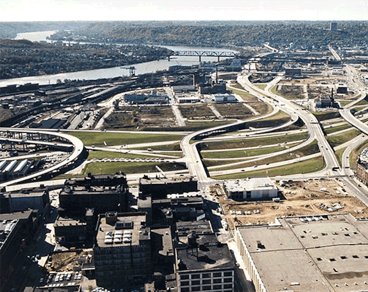
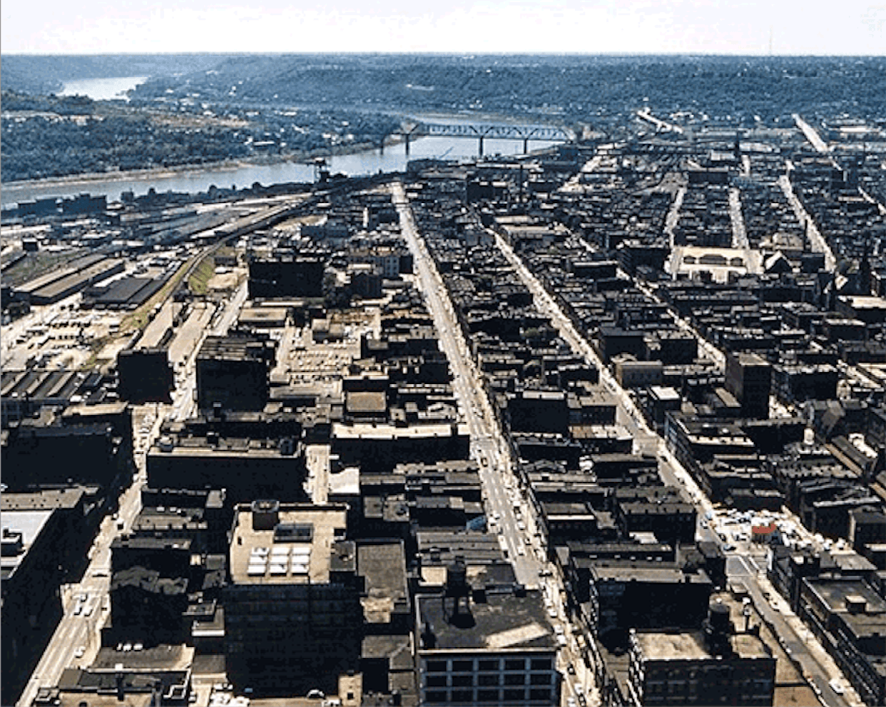
These photos from Cincinnati show how much destruction was wrought between 1958 (left photo) and 1966 (right photo) to build the interchanges for Interstates 71 and 75 just west of downtown.

Urban Renewal and Racial Displacement: How Highways Targeted and Destroyed Communities of Color

The urban renewal movement sought to enhance cities’ economic vitality by targeting and systematically removing housing and businesses deemed substandard. These practices disproportionately targeted communities of color because these areas had been neglected and denied investment for so long. Rather than finding ways to invest in them and build them up, those with the power used the new renewal programs to raze entire neighborhoods and displace hundreds of thousands of residents. The USDOT estimates that construction of the interstates displaced 475,000 households and over a million people in less than two decades.

Communities of color were often deliberately and intentionally targeted and razed by avowed racists who selected the routes. In the South especially, it was not uncommon for openly racist leaders to control those decisions.

Urban Renewal and Racial Displacement: How Highways Targeted and Destroyed Communities of Color

The D.C. Freeway Revolt and the Coming of Metro, Part Six.

In Alabama, Sam Englehart, who was also the leader of a hate group known as the Alabama White Citizens Council, became the Director of the Alabama Highway Department. In one of the most egregious but far from atypical examples, Englehart personally intervened to reroute I-65 through prosperous Black neighborhoods in West Montgomery, even intentionally targeting the home of civil rights leader Ralph David Abernathy for destruction. Residents of these communities lacked the political power needed to halt such projects.2

When Congress approved the Federal-Aid Highway Act of 1956, it authorized what was then the largest public works program in U.S. history. The law promised to construct 41,000 miles of an ambitious interstate highway system that would crisscross the nation, dramatically expanding America's roadways and connecting 42 state capital cities and 90 percent of all American cities with populations over 50,000. Its goal was to eliminate unsafe roads, inefficient routes and traffic jams that impede fast and safe cross-country travel.

Find out More at History.com
quoteStart

During the Senate confirmation hearing before the Committee on Commerce on January 15, 1969, several Senators asked about the nominee’s (John Volpe) views on highways and his actions as Governor. Senator Philip A. Hart (D-Mi.) told Governor Volpe that ‘in the eyes of minority groups,’ the Federal highway program ‘is an enemy, because they do not generally run the highway through my house or yours; it is the fellow whose property is cheaper, quicker to get, but who when he is moved has less opportunity to relocate successfully than you and I have.

Richard Weingroff, Federal Highway Administration (FHWA)

Highways as Tools of Segregation: How Urban Renewal and Design Choices Excluded Communities of Color

While highways became an essential tool for “urban renewal,” all manner of resources were employed to segregate or demolish communities of color. Robert Moses intentionally built bridges too low for transit vehicles to pass under, effectively keeping the lower-income and people of color who rode transit in higher shares from accessing certain neighborhoods, parks, airports, and job centers.3

New highways—fast, easy routes between work and home—succeeded in bringing suburbanites into cities for work, but they also systematically carved out the urban core of cities, harmed communities of color, and failed to preserve the local economy or otherwise make the urban areas more enticing to the white suburbanites.

Highways as Tools of Segregation: How Urban Renewal and Design Choices Excluded Communities of Color

The interstate system has carved up cities small and large, rendering it either impossible or extremely dangerous to get around with a vehicle. Two people attempt to navigate an interstate frontage road without sidewalks in Jackson, MS. Photo courtesy of Scott Crawford.

Highways as a Legacy of Exclusion: How Historical Policies Shape Ongoing Transportation Inequities

Highways were just one part of a larger system of exclusionary practices put into place with the help of federal investment and policies. However, once highways were in place, they created a new set of unforeseen problems and costs, which federal, state, and local governments would be forced to grapple with for years to come, even to the present day.

This more openly racist past may be behind us, but that history still shapes the present. And the fact that our federal transportation program and most state transportation agencies were chartered or tasked with building new highways as their primary role for decades is the reason why a deeply held system of assumptions, measures, models, and other hidden factors continue to produce the same inequitable outcomes, regardless of the motives of those in charge.

Read more in Part II

Download Divided by Design 2023

Download Report
img
logo
1350 I St NW Suite 425 Washington, DC 20005
info@smartgrowthamerica.org

Subscribe to our newsletter

Livable places. Healthy people. Shared prosperity.

© 2025 Smart Growth America. All rights reserved

Accessibility